-
About
- General Information Learn more about the Sacramento County Airport System. Click here for information such as the system’s mission statement, awards, partners and more.
- News & Events Keep up with everything happening at the Sacramento County Airport System and our airports. Past, present and future news, press releases and events.
- Community Outreach & Customer Service Social Media. Speakers Bureau. Customer Service. PR. Be part of our conversation with the community.
- Planning & Design Interested in the master plan for future expansion and development of airports within our system? Everything you need to know is right here.
- Safety Management Systems Find out about our systematic and structured approach to safety management as well as access to our online form for reporting a safety concern.
- WRAPm 2022 Western Region Airport Property Managers
- Reports Peruse reports and information on airport system issues.
- Aviators Restaurant Survey Files Executive Airport survey summary, survey data, and paper survey copies.
-
Opportunities
- Employment (Jobs) The Sacramento County Airport System and our partners are always looking for new team members. Explore jobs throughout the system here.
- Concessions Resources for Developing a Concessions Business
- Bids & Requests Current proposals, bids and requests are listed here.
- Leasing With leasing opportunities at 3 different airports, the County Airport System has the right space to fit your needs. Explore available spaces here.
- Permits Permits are critical to doing business with the Sacramento County Airport System for purposes such as demonstrations, transportation, film and events.
- Advertising More than 10 million passengers pass through SMF every year, making it the perfect place to share your company's message.
- ACDBE/DBE Programs The Sacramento County Airport System is dedicated to helping minority and women-owned businesses through ACDBE/DBE Programs
-
Environment
- Noise The Sacramento County Airport System has a long history of working with stakeholders to reduce aircraft noise exposure for local residents.
- Wildlife Management The County Airport System is dedicated to ensuring public safety through our comprehensive Wildlife Hazard Management Program.
- Water Conservation Water is one of our most precious resources. Learn what Sacramento International Airport is doing to reduce water consumption
- Sustainability We’re working to make flying greener. Find out more about our efforts to reduce the energy use and overall ecological impact of our airports.
- Contact Us
-
Search
Sacramento County
Select Language
- Department of Airports
- International (SMF)
- Mather (MHR)
- Executive (SAC)
- Franklin (F72)
Select Language
Information for Prospective Homebuyers
Moving to the area around SAC? Find out about the operation of the Airport here.
Potential homebuyers should be aware of planned airport growth and the exposure to aircraft operations in the area near Executive Airport - now and in the future.
Prospective homebuyers are encouraged to contact the Sacramento County Airport System at planenoiseinfo@saccounty.net and provide the address of the prospective home. Noise Office staff can assist buyers in understanding the range and nature of airport/aircraft exposure to which a particular property may be subject. Prospective homebuyers concerned with aircraft overlfight exposure should always spend sufficient time at their potential new location to gain a thorough understanding of the area and any disturbances they may encounter.
Executive Airport is primarily a general aviation facility and has three runways: Runway 02/20, Runway 12/30 and Runway 16/34. Runway 20 is used most frequently because it is the longest runway and due to the fact that the majority of the time during any given year winds in the Sacramento region are from the south. Runway 20 is used approximately 74 percent of the time in a given year. When winds are from the north Runway 30 is used; this equates to approximately 15 percent of the time in a given year. Runway 02 is used approximately 7 percent of the time and all FAA published instrument approach procedures are designed with approaches to runway 02. Runway 12 is used approximately 4 percent of the time. Runway 16/34 is infrequently used.
- Executive Airport Diagram (PDF) – Download
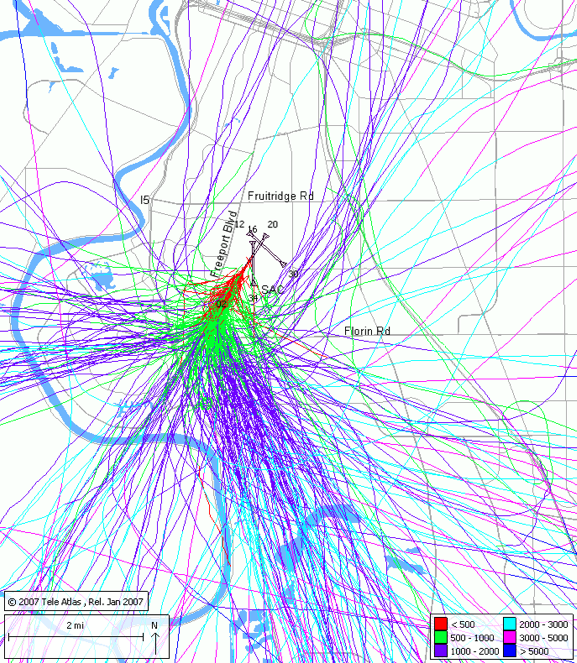
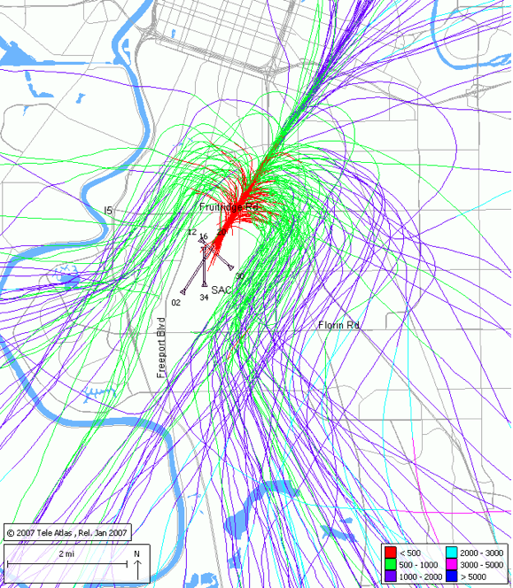
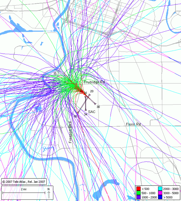
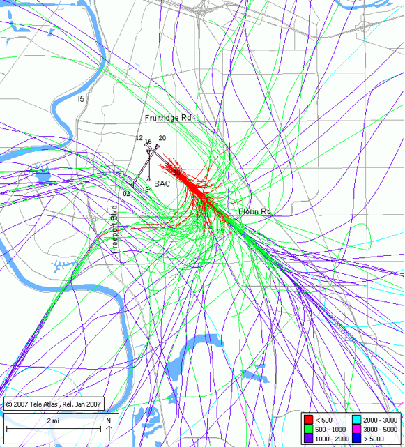
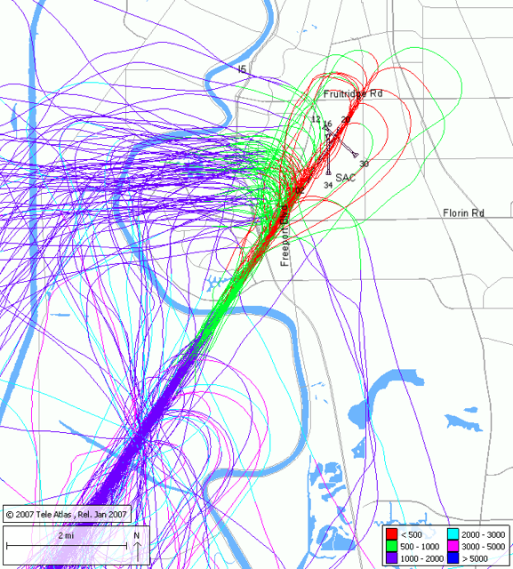
The primary areas of concern have historically been centered around the use of Runway 30 and practice Instrument Landing System (ILS) approaches to Runway 02. Exhibits 1 and 2 depict the general areas of aircraft overflight during the predominant utilization of Runway 20. Exhibits 3 and 4 depict the general areas of aircraft overflight during the use of Runway 30 when winds are from the north. Aircraft will arrive from the southeast and depart to the northwest on Runway 30. This results in overflights of the South Land Park area. Exhibit 5 depicts the customary practice approaches to the ILS for Runway 02. This results in overflights of the Greenhaven-Pocket area.
These exhibits are not meant to represent the level of noise but rather the general location by operation mode and altitudes of aircraft. The exhibits are samples of flight tracks in the vicinity of the Airport and were developed using various time periods (day, week, month, etc.) to show in general terms what the flight patterns in the vicinity of the Airport may look like. Flight track locations naturally vary from day-to-day due to wind speed and direction, weather fronts, pilot techniques, and the location of other air traffic in the local area.
- Airport Disclosure Brochure for Real Estate Professionals (PDF) – Download
Airport Website
Translate
